Located on the northeastern coast of Vietnam, Ha Long Bay encompasses a vast area of about 1,500 km2, with nearly 2,000 large and small limestone islands creating a unique and diverse geological system. The formation of these limestone islands is the result of millions of years of geological changes, creating a majestic landscape of immense scientific value. In this article, VDS Travel will help you gain a deeper understanding of the structure and formation of the limestone islands in Ha Long Bay.
See more: Explore the Cave System in Ha Long Bay
Limestone Structure of Ha Long Bay
Ha Long Bay is a pure limestone region eroded into a mature fengcong and fenglin karst landscape. This process occurs due to the subaerial erosion of limestone, followed by marine submergence and slight modification at a late stage. Hundreds of rock islands forming the most beautiful and famous landscapes in the bay are isolated towers within a classic fenglin karst landscape, where intercalated plains are submerged by the sea (Figure 1).
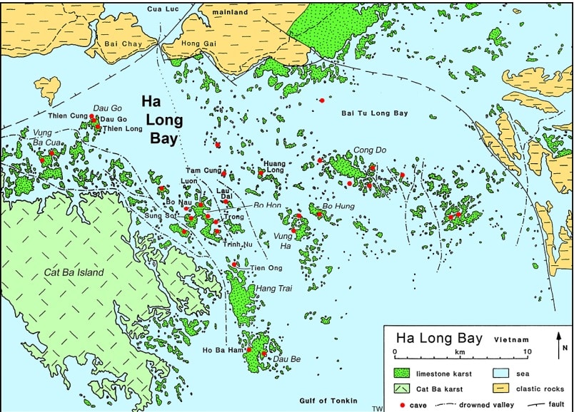
Photo 1: A simple map of Ha Long Bay, showing major islands, prominent geology, and naming several major caves
Most towers reach heights between 50 and 100 m, with height-to-width ratios reaching up to about 6. Many towers possess vertical walls on all or most sides; they continue to develop due to rockfalls and major fractures. In 1997, a large slab of rock detached from a small island north of Cat Ba to create a new vertical face; the damaged surface consists precisely of vertical fractures, part of which opened up to form a cave later partially filled with large stalactites, and the rockfall block of approximately 500 m3 currently lies on the sea and is being eroded by dissolution and wave action.
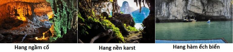
Many towers have very old cave remnants preserved inside, and many feature basal caves that are remnants of notches at various levels (Figure 2). The clusters of limestone hills form larger islands in Ha Long Bay and represent prime examples of fengcong karst. Peaks generally stand at elevations of around 100 m above sea level, with the highest peaks reaching over 200 m. Their shapes are predominantly very steep cones; except around their marine margins, vertical cliffs are only minor components, as they are not truncated in places where their internal linear trends do not reach base level. These conical hills also contain remnants of old cave passages. Some fengcong hills have distinct ridges or flanks formed on dipping bedding planes within the limestone; apart from these locations, geological structure has very little influence on the limestone hill cross-sections.
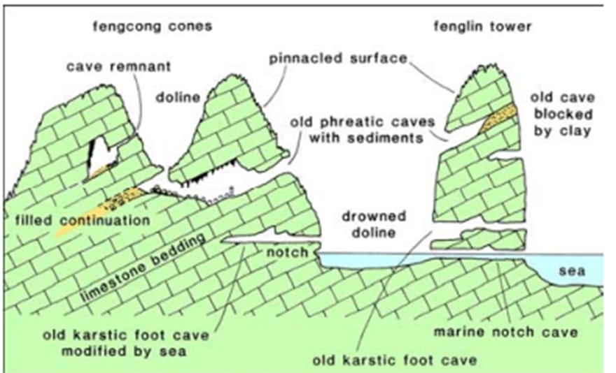
Figure 2. Diagram showing the main cave types in the limestone mountain region of Ha Long Bay.
A special feature of Ha Long Bay is the presence of numerous lakes situated inside the limestone islands. Dau Be Island at the entrance of the bay features six enclosed lakes, including Ba Ham Lake. All lakes on this island lie within sinkholes in the fengcong limestone and are referred to as hong in other regions of Southeast Asia (Figure 3). Their depth profiles have not been surveyed; most appear deep, but some feature shallow flat areas immediately below water level, and most exhibit marine solution notches around their walls. They are tidal, with seawater moving freely through the limestone, at some locations via sea-level caves passable by boat, but at other locations through inaccessible fracture networks. One freshwater lake is known on the eastern side of Cong Do Island (Figure 6); it may persist on a clastic sediment floor, but its geomorphological details remain poorly understood.
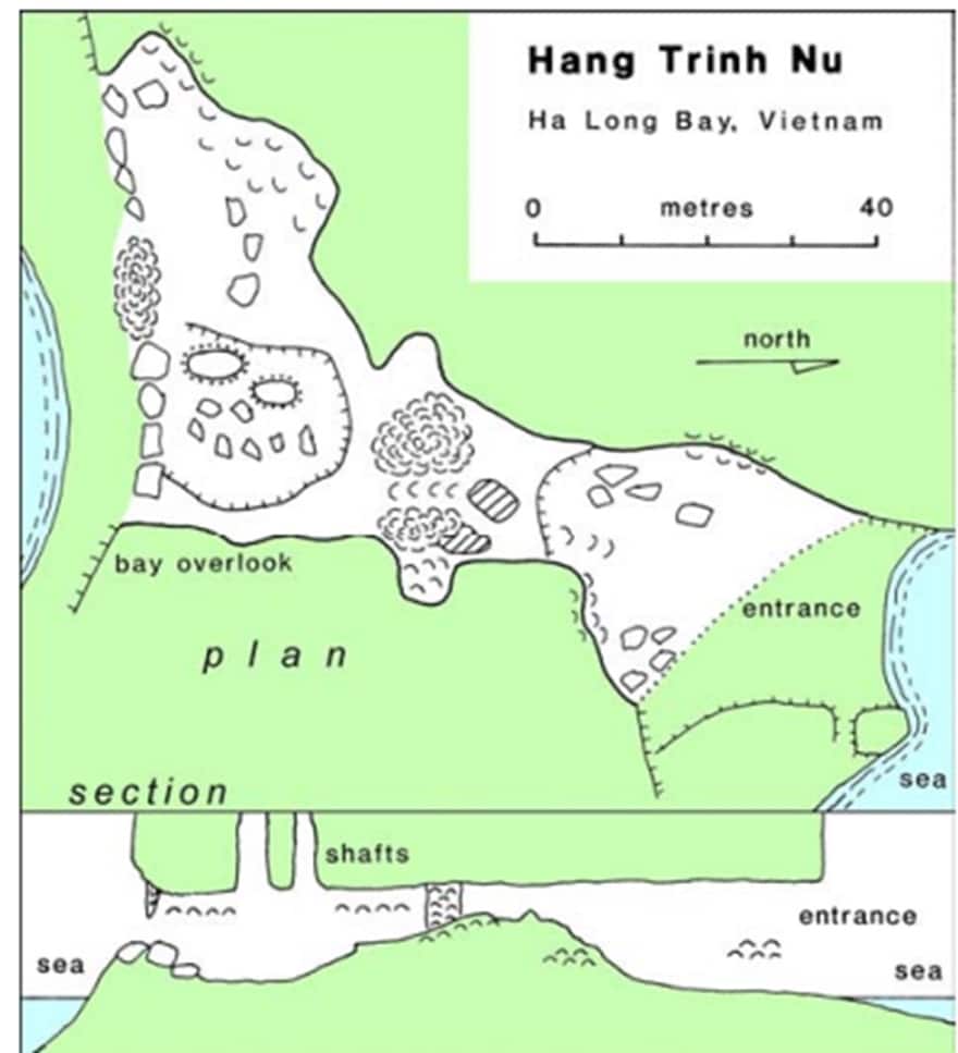
Figure 3 Diagram and cross-section of Virgin Cave on Bo Hon
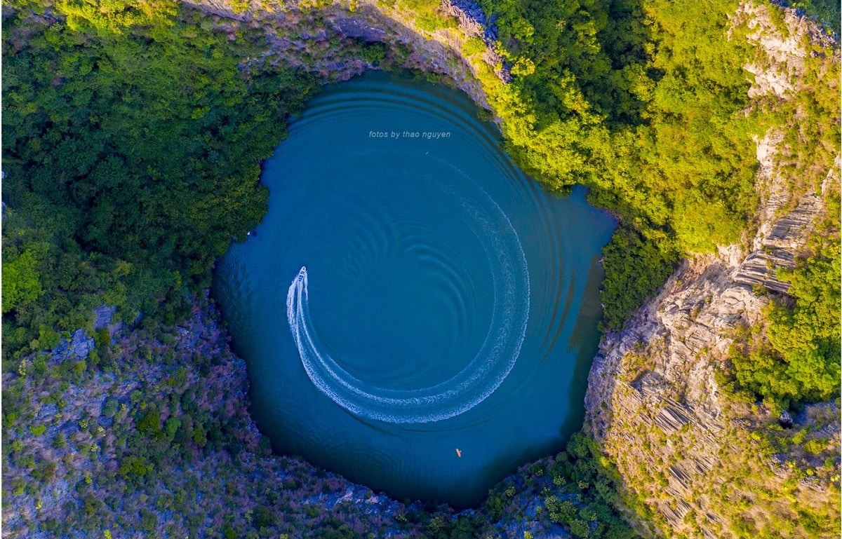
Figure 4. Dolphin Lake in the interior of Cong Do Island (Photo: Thao Nguyen)
Many shallow marine areas between the limestone islands appear to be submerged limestone plains; most of the bay has depths under 10 m. Clastic sediments cover most of the seabed; much of it is likely of marine origin, although remnants of subaerial sediments from the original limestone plains may persist within buried sequences. Submerged plains along the inner margins of the bay receive drainage from the Red River and mainland flowing onto the limestone. The patches of fengcong limestone currently forming larger islands likely originated from areas with slightly higher ground or fewer gradient lines on the initial surface from which modern karst hills developed. All limestone surfaces across the Ha Long Bay archipelago are disrupted by dissolution. Remnant peaks, ridges, and blades all exhibit razor-sharp rillenkarren surfaces, producing a harsh terrain that is very difficult to traverse. Jagged fractures continue to deepen and lack continuous soil cover as well as subsoil rundkarren. Much of the organic soil accumulates within certain limestone fissures, where it provides rooting environments for the prevalent scrub vegetation. All limestone surfaces are black due to blue-green algae living in the outer surface crust of the rock and supporting its pitting via bio-dissolution.
Erosion of Limestone by Seawater
The marine transgression into the Ha Long Bay limestone mountains introduced an additional factor causing the truncation of limestone islands. The most conspicuous feature is the principal marine notch cutting into almost all rocky coastlines. Its deepest zone typically stands about 3 m high, situated between normal high and low tide levels. This represents a complex feature, often featuring a shoulder at mid-height and a smaller cut extending another meter higher; the latter may reflect erosion caused by high wave action and elevated spring tides. Subsequent notches at higher sea levels were cut during periods of higher sea levels and are now inactive. Features below low tide level have not been observed, but there is no evidence of any broad wave-cut platforms. Across the bay, there is no variation in notch dimensions related to exposure to larger waves originating from the open sea. This indicates that the notches were cut largely through limestone dissolution. Seawater is generally saturated with calcium carbonate, and consequently limestone dissolution depends on the active microenvironment created by algae in the surface layers of the limestone. Dark coatings containing green algae, ubiquitous on subaerial limestone outcrops, extend down cliffs into the intertidal range; marine algal forms are likely equally widespread but remain unrecorded. Limestone dissolution is also enhanced at sea level by the mixing of seawater and freshwater within the archipelago’s fracture system. Notches are a feature of coastal limestone cliffs worldwide, but notches in Ha Long Bay are exceptionally developed and at many locations extend back into arches and caves (see below). Undercutting at marine notches currently represents the primary process driving the erosion and retreat of limestone cliff faces. Marine erosion not only adds notches to the cross-sections of limestone islands but also maintains the steep slope surfaces of fenglin towers, thereby preserving the spectacular character of the karst landscape (Figure 5).

Figure 7 A small rock island in Ha Long Bay; remnant of a fenglin tower, it is truncated by a marine notch, and a section of cliff recently detached so that it now rests on a submerged rock platform.
Many islands in the bay feature narrow peninsulas formed by high limestone ridges enclosed by cliffs; these separate and outward-looking bays are much wider than the intervening land strips, as at the northern end of Dau Be Island. Ridges linking peak chains are generated in fengcong karst terrain, where favorable large gradient line patterns exist. Under normal weathering conditions, they break down into lower columns, ultimately leaving isolated karst peaks. The very narrow limestone areas of Ha Long Bay are atypical of subaerial fengcong karst. They represent consequences of more rapid lateral expansion of central depressions and appear to be a feature of marine erosion. Their presence points to an important component of marine activity during the geomorphological evolution of Ha Long Bay.
Prices and Sightseeing Routes for Famous Islands and Limestone Mountains in Ha Long Bay
To explore the beauty of islands and limestone mountains in Ha Long Bay, visitors need to purchase sightseeing tickets according to fixed routes. Afterward, you can choose boat/cruise types (day trips or overnight stays) and specific itineraries matching your preferences.
If visitors wish to explore limestone mountains, you can check ticket prices and tour boat lists at: https://vdstravel.com/gia-tau-du-lich-tham-vinh-ha-long
Introduction to famous islands and limestone mountains featured across routes:
-
Trong Mai Islet (Fighting Cocks) (VHL1, VHL5): The symbol of Ha Long Bay, two limestone rocks shaped like a pair of chickens fighting each other, a familiar image across tourism publications.
-
Dinh Huong Islet (Incense Burner) (VHL1, VHL5): An island shaped like an incense burner, holding spiritual significance, featured on Vietnam’s 200,000 VND banknote.
-
Cho Da Islet (Dog Stone): A small island shaped like a sitting dog.
-
Titov Island (VHL2): A famous island featuring a crescent-shaped beach with smooth white sand, where visitors can climb to the summit to admire panoramic views of Ha Long Bay from above. One of the “must-visit” spots in Ha Long.
-
Soi Sim Beach (VHL2): Soi Sim Island possesses a pristine beach, crystal-clear seawater, and a diverse ecosystem. Suitable for those loving natural, peaceful beauty.